
As Philip Island locals we intimately know the island, its flora and fauna for any given season. Almost everyplace on the island has the potential for a good picture but we have compiled our Top 10 (actually 11) of the places we love that are off the beaten track and may be unknown to those who are just visiting. We’ve given you google map coordinates and how to get there info to make it as easy as possible. Please remember that the island has a unique and fragile ecosystem. Please respect signs and stay on designated tracks at all times. I hope you enjoy the island as much as we do.
Our Top 10 Phillip Island Photography Locations ranked from 11 to 1:

11. Newhaven Yacht Club Lookout
What’s the Shot? - Sunrise
Google Map Link - https://goo.gl/maps/CkmYLdiohfC2
Getting There - You can drive right up to the best spot along Forrest Ave
Description - Forrest Rd overlooking Newhaven Yacht Club is the best Sunrise spot hands down on the island. If the sunrise fizzes you can always run down the road and see what’s happening around the two Newhaven jetties. There’s always pelicans and other interestings there too.
10. Cowrie Patch Beach
What’s the Shot? - Sunset is the best with Sentinel Rock in the foreground
Google Map Link - https://goo.gl/maps/3cMKkseZLxq
Getting There - WARNING - LOW TIDE ONLY. Access to The Cowrie Patch is only possible at low tide, please consult tide chart on the day you wish to go. Head South down Woolamai Beach towards the staircase leading up to the Woolamai track. Once you reach the staircase, continue along the base of the cliffs. Follow this often rocky and slippery route to where the coastline makes a marked L turn Westward. You’ll enter the Cowrie Patch through a narrow gap between the cliff face and Sentinel Rock - about 1.5 kilometers.
Description - This is the island’s hidden and secret beach. You can not see it from surf beaches or walking tracks. The Cowrie Patch is a beach made from the surf pounding away at the surrounding granite. It’s a coarse sand beach unlike Woolamai. Sentinel Rock, a large granite monolith, guards the entrance to The Cowrie Patch.

9. Red Rocks
What’s the Shot? Sunset, especially sunsets with a model
Google Map Link - https://goo.gl/maps/E2UCetAzbr42
Getting There - Drive to the end of Red Rocks Rd in Cowes, turn left on Penguin Ave. Go to the end of Penguin Ave and park in the small car park. Take the staircase down to the beach.
Description - Red Rocks is the perfect place to get a beautiful calm sunset beach shot. The red rocks (ancient volcanic ash) looks amazing and provides nice contrast to the beach and blue water. It’s also usually out of the southerly wind making it a good spot to take a model for a sunset shoot.

8. Oswin Roberts Reserve
What’s the Shot? Coastal forest with ample wildlife including many bird species, wallabies, echidnas and the occasional koala.
Google Map Link - https://goo.gl/maps/aFnXSTZi7dr
Getting There - Oswin Roberts Reserve is directly behind the Philip Island Koala Reserve. Turn off of Phillip Island Rd at Coghlan Rd then take an immediate right onto the gravel Harbison Rd. The reserve is clearly marked down Harbinson Rd.
Description - The Reserve has several kilometers of hiking and biking trails that link to the Rhyll Conservation Walk. Along the trails are tall eucalypts and groves of Coastal Tea Trees. This is an excellent walk to see wildlife and the interior of the island.

7. Cat Bay
What’s the Shot? Long exposure of old jetty
Google Map Link - https://goo.gl/maps/X6L8XkyNRBv
Getting There - Take the Flynn’s Beach exit off of Ventnor RD, Summerlands. This is just before you reach the Phillip Island Penguin Parade.
Description - Flynns beach looks out into Cat Bay. Near the Southern end of the beach you will see the remains of an old jetty. This location makes a great long exposure shot especially with a few clouds in the sky.

6. Magiclands
What’s the Shot? Beautiful rock formations covered in neon green sea moss.
Google Map Link - https://goo.gl/maps/ZZ7De5xfT122
Getting There - Park at the Woolamai Beach car park at the very end of Woolamai beach RD, Cape Woolamai. Walk South along the beach and continue past the staircase that leads up to the Cape Woolamai track. Magiclands is about 50 meters beyond the staircase.
Description - Magiclands is best visited at low tide to see the rock formations covered in a bright or neon green sea moss. The rock formations and moss continuously change depending on how much sand has been deposited or removed by storms and wind. This is a beautiful area that is rarely visited by tourists.

5. Kitty Miller Bay
What’s the Shot? Landscape and Intimate Landscapes.
Google Map Coordinates - https://goo.gl/maps/ThS7WKkYsL62
Getting There - Kitty Miller bay is at the very South end of Kitty Miller Bay Road, Ventnor
Description - Beautiful small bay. It’s one of the most geologically rich areas on the island. Black rocks are volcanic basalt and red rocks are volcanic ash from a later geologic period. The West side of the bay has hexagonal basalt and beautiful orange lichen. Anywhere around the bay can provide great images but check out the Western entrance to the bay for the most interesting rock formations.

4. Rhyll Conservation Walk
What’s the Shot? Wildlife, Landscape, Mangrove Swamp Boardwalk
Google Map Coordinates - https://goo.gl/maps/Z5DZerC5pQ32
Getting There - The Rhyll Conservation Walk is between Cowes and Rhyll along the Cowes-Rhyll Road. The entrance and car park is clearly marked as Conservation Hill Reserve. Take the due North walking track.
Description - The Rhyll Conservation walk is a nice trail between Conservation Hill Reserve and Rhyll. At the trailhead a mob of Wallabies can usually be seen. The path leads down to the Rhyll Inlet and a gorgeous boardwalk through the Mangroves.

3. Wreck of the SS Speke
What’s the Shot? The iron remains of the bow of the SS Speke. Long exposure and astro are the best shots here.
Google Map Coordinates - https://goo.gl/maps/9xHqM2gguWz
Getting There - From Kitty Miller Bay follow the beach around the left (East) side and take the track that leads up on the headland. Follow track over headland and to the next beach. The wreck will be at the bottom of the track on the reef.
Description - The wreck sits on the reef. During high tides, water will surround the wreck.

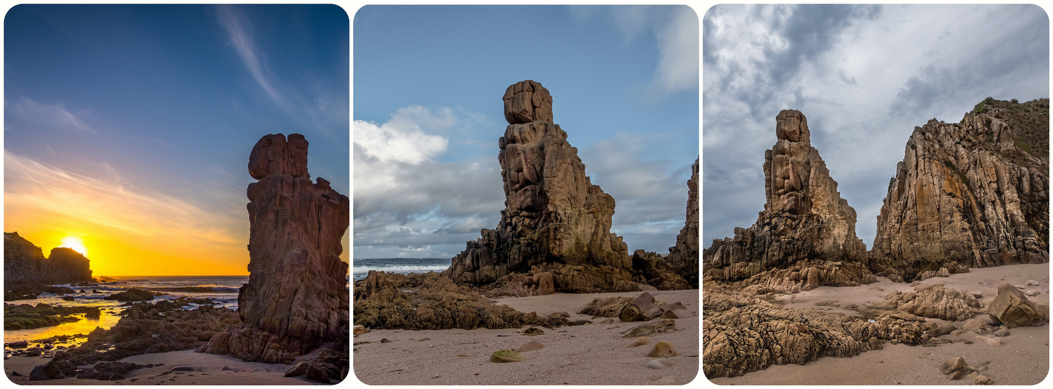
2. The Pinnacles
What’s the Shot? Landscape shot at sunset above the Pinnacles
Google Map Coordinates - https://goo.gl/maps/pL6UCZuZVKA2
Getting There - Walk South (left) on Woolamai Beach about 500m and go up the staircase to the Cape Woolamai Track. From there, walk along the track. Take the right fork and stay on the track that runs along the cliff side. The Pinnacles viewing platform is about 2.5k from Woolamai Beach car park.
Description - *DO NOT DESCEND TO THE BOTTOM FROM THE TOP* The Pinnacles are the remnants of an ancient volcano. There are beautiful views across the island’s ocean coastline from the viewing area. The Pinnacles and Castle Rock (to the right of the Pinnacles) are perfectly situated for sunset shots. This is also the best vantage point on the island to experience the return of the Short Tailed Shearwaters on Summer Evening and to watch whales cruise past the island in Winter time. The bottom of the Pinnacles may be accessed at LOW TIDE by walking along the beach and rocks the entire way. Access from the top is forbidden due to the number of Short Tailed Shearwater burrows and environmental sensitivity of the area. Significant environmental damage has been done by photographers descending to the bottom.

1. Cadillac Canyon
What’s the Shot? Slow exposure of water flowing into the Canyon structures.
Google Map Coordinates - https://goo.gl/maps/A9TUyqYLz3k
Getting There - Cadillac Canyon is located at the far end of Bore Beach. To get to Bore Beach, go to the very end of Potter’s Hill Road, San Remo.
Description - Cadillac Canyon is a basalt reef that has a couple of deep canyons carved by water action over millions of years. This location provides spectacular waves during big swell periods and even at low tide, has ample water flowing in and out of the canyon structures. WARNING - keep an eye on the incoming waves at all time. Rogue waves do hit the basalt platform and could easily sweep a photographer out to sea.